Lost Maya City Found Deep in Mexican Jungle May Hold Keys to Civilization's Collapse
Archaeologists have discovered an untouched, 1,000-year-old Maya city in Mexico's Campeche state, using LiDAR technology to reveal a 43-foot pyramid and pristine monuments.
By Factlen Editorial Team
- Field Archaeologists
- Prioritize ground-truthing, physical excavation, and the preservation of unlooted sites.
- LiDAR Technologists
- Focus on macro-scale data and mapping the true density of ancient civilizations.
- Paleoclimatologists
- Analyze archaeological sites for environmental data to understand climate impacts.
- Indigenous Heritage Advocates
- View the discoveries as a testament to the resilience and advanced engineering of their ancestors.
What's not represented
- · Local Indigenous Communities living near the Calakmul Biosphere Reserve
- · Ecologists monitoring the impact of archaeological excavations on the protected biosphere
Why this matters
The discovery of an unlooted, pristine Maya city provides archaeologists with an uncontaminated time capsule. By studying its perfectly preserved monuments and water systems, scientists can gather hard evidence to solve the centuries-old mystery of why the Maya civilization collapsed.
Key points
- Archaeologists have discovered Minanbé, a 1,000-year-old Maya city hidden deep within Mexico's Calakmul Biosphere Reserve.
- The 15-hectare site features a 43-foot pyramid temple, enclosed plazas, and an extensive water management system.
- Aerial LiDAR technology penetrated the dense jungle canopy to reveal the city's geometric structures before ground teams arrived.
- The city's extreme remoteness has kept it uniquely intact and unlooted, preserving 14 carved altars and stelae.
- Minanbé flourished during the Late Classic period and may hold critical clues to the mysterious collapse of the Maya civilization.
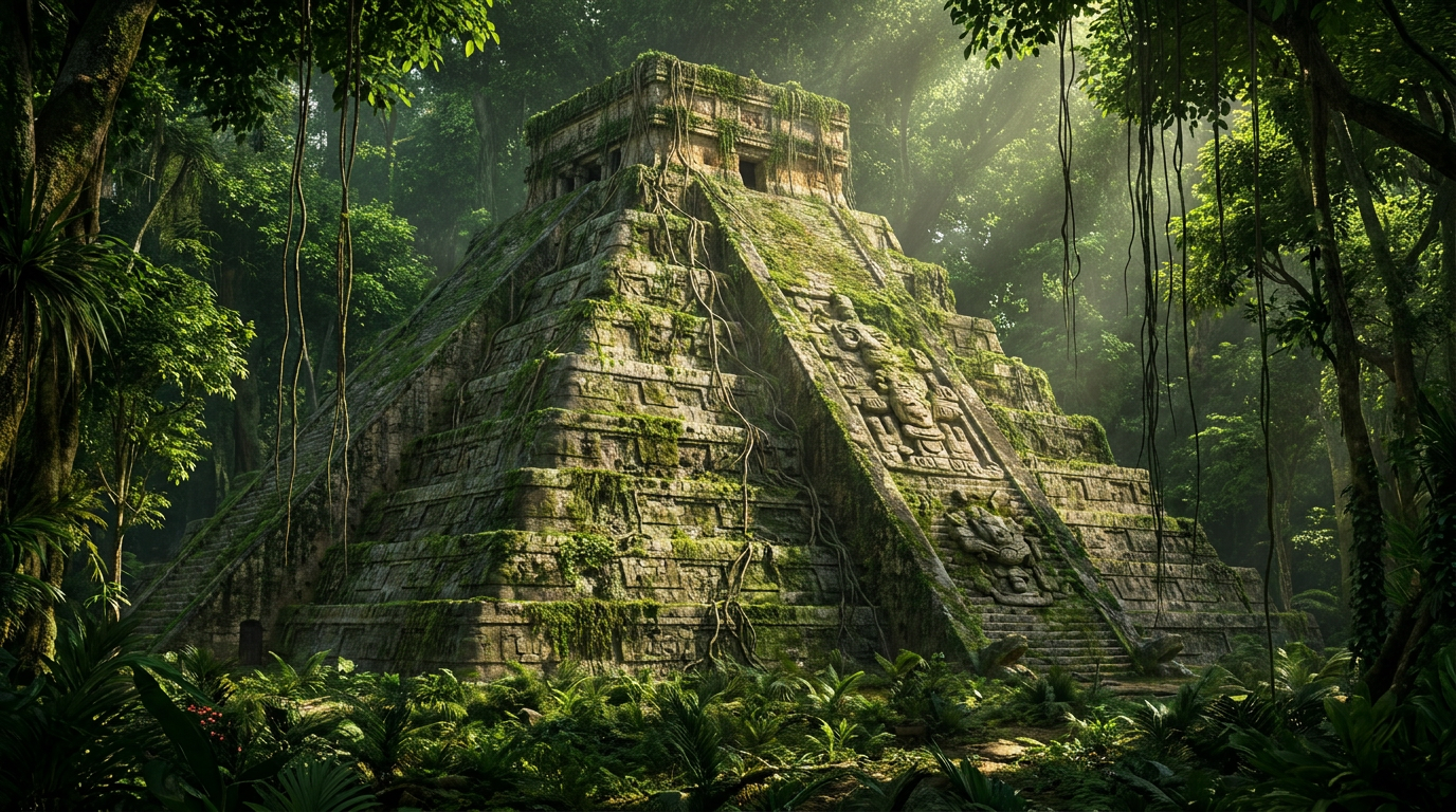
Deep in the Calakmul Biosphere Reserve of Campeche, Mexico, a pristine ancient Maya city has been unearthed after lying hidden beneath the dense jungle canopy for over a millennium. Named Minanbé—a Yucatec Mayan phrase translating to "there is no road"—the site represents one of the most significant archaeological finds in recent memory. The discovery provides a rare, uncontaminated glimpse into a civilization that mysteriously collapsed centuries before European contact. By combining cutting-edge remote sensing technology with grueling physical expeditions, researchers have mapped a sprawling urban center that defies previous assumptions about the region's historical population density.[1][2]
Unlike many historical ruins across Mesoamerica that have been compromised by modern logging operations, agricultural expansion, or illicit artifact trafficking, Minanbé remains uniquely intact. Excavation leader Ivan Šprajc, an archaeologist with the Slovenian Academy of Sciences and Arts, noted that the city's extreme remoteness acted as a natural shield. This isolation has preserved a pristine time capsule of the Late Classic period, allowing researchers to observe the exact state in which the city's original inhabitants left it. The undisturbed stratigraphy means that every fallen stone and buried ceramic piece remains exactly where it was deposited centuries ago.[1][6]
Ground verification of the site revealed a sprawling 15-hectare urban center that served as a major regional hub. At its heart stands a massive 43-foot-high pyramid temple—roughly the height of a modern four-story apartment building—surrounded by palatial structures and enclosed plazas. The architectural arrangement suggests a highly organized society capable of mobilizing significant labor forces. Beyond the monumental architecture, the city features an extensive water management system seamlessly integrated with the local wetlands, demonstrating the inhabitants' advanced ecological engineering and their ability to sustain large populations in a challenging tropical environment.[2][3]
The discovery of Minanbé was made possible by Light Detection and Ranging (LiDAR), a remote sensing technology that has fundamentally transformed the field of archaeology. LiDAR systems, typically mounted on low-flying aircraft or drones, fire hundreds of thousands of laser pulses per second toward the Earth's surface. While many of these pulses bounce off the dense jungle canopy, a fraction penetrate through the leaves and branches to strike the ground below. By measuring the exact time it takes for these pulses to return, computers can generate a highly accurate, three-dimensional topographical map of the forest floor.[3][7]

When applied to the dense Central Maya Lowlands, LiDAR digitally strips away the vegetation to reveal the geometric signatures of human-made structures that are completely invisible to the naked eye. This mechanism exposes causeways, agricultural terraces, defensive walls, and pyramids hiding in plain sight. For decades, archaeologists relied on painstakingly walking through the jungle, hacking away at vines to see if a pile of rocks might be an ancient home. LiDAR has revolutionized this process, shifting Mesoamerican archaeology from blind, localized exploration to targeted, data-driven expeditions that can map entire regional networks in a matter of days.[7][8]
Despite the clarity provided by the aerial map, physically reaching Minanbé required immense physical endurance and logistical planning. A joint Mexican-Slovenian research team, operating with the authorization of Mexico's National Institute of Anthropology and History (INAH), had to navigate some of the most unforgiving terrain in the Yucatán Peninsula. The team spent days hacking a three-mile path through dense, thorny vegetation using machetes just to set foot on the site. The grueling journey underscored exactly why the city had remained hidden from looters and loggers for more than a thousand years.[1][4]
The architectural style and initial ceramic findings indicate that Minanbé flourished during the Late Classic period, spanning approximately 600 to 900 C.E. This era marked the absolute zenith of Maya civilization, a time of explosive cultural, scientific, and architectural achievement. During this period, the Central Maya Lowlands were not a sparsely populated jungle, but a thriving megalopolis. Estimates suggest the region supported a staggering population of between 9 and 11 million people, rivaling the density of modern urban centers and requiring highly sophisticated agricultural and political systems to maintain stability.[1]
The architectural style and initial ceramic findings indicate that Minanbé flourished during the Late Classic period, spanning approximately 600 to 900 C.E.
Among the most critical pieces of evidence recovered from the jungle floor are 14 carved altars and stelae—upright stone slabs typically inscribed with hieroglyphs and relief sculptures of rulers or deities. These monuments served as the public records of the Maya, documenting royal lineages, military victories, and significant astronomical events. Preliminary analysis of an engraved calendrical element on one of the altars suggests it was carved in the late seventh century, making it the oldest dated monument discovered at the site and providing a firm chronological anchor for the city's rise to prominence.[1][2]

The presence of a sophisticated water management system at Minanbé highlights the Maya's advanced understanding of hydrology and ecological engineering. The Yucatán Peninsula experiences intense seasonal variations, with heavy rains followed by punishing dry seasons. To survive, the inhabitants of Minanbé heavily modified the surrounding wetlands, constructing reservoirs, dams, and canals to capture and store water. These infrastructure projects were absolutely crucial for sustaining a large urban population through months of drought, and their eventual failure may hold the key to understanding why the city was ultimately abandoned.[2][8]
Minanbé's untouched state makes it a critical, uncontaminated laboratory for investigating the mysterious Maya collapse. Between 850 and 1000 C.E., dozens of thriving city-states across the Lowlands were rapidly and permanently abandoned, a demographic catastrophe that has puzzled historians for centuries. Because Minanbé was not disturbed by later Mesoamerican inhabitants or modern looters, the archaeological stratigraphy—the sequential layering of soil and artifacts—remains perfectly preserved. This allows researchers to read the final days of the city like a book, searching for the exact sequence of events that led to its downfall.[1][5]
Researchers are actively searching the site for specific evidential markers of decline. Evidence of sudden, panicked abandonment—such as unfinished architectural projects, deliberately smashed ceramics, or defaced stelae—would strongly indicate political upheaval, peasant revolts, or violent external conflict. Conversely, if the soil record and wetland sediment cores reveal signs of prolonged, severe drought leading to agricultural failure, it would bolster the prevailing theory that climate change and environmental degradation were the primary drivers of the civilization's collapse.[2][5]
While the structural data provided by LiDAR is highly robust, offering definitive proof of the city's layout and scale, the epigraphic evidence remains shrouded in uncertainty. Weathering over a thousand years of heavy tropical rain has severely eroded many of the limestone carvings on the stelae. Extracting precise historical narratives, names of rulers, or records of conflict from these stones will require meticulous digital reconstruction, including 3D photogrammetry and raking-light photography, to decipher the faded hieroglyphs.[1][4]
Minanbé must be understood not as an isolated outpost, but as a node in a vast, interconnected civilization. Recent LiDAR surveys across the state of Campeche have consistently revealed that the Maya world was far more densely populated and integrated than previously believed. Rather than a collection of isolated city-states separated by impenetrable jungle, the region was a continuous web of urban centers, sprawling suburban agricultural terraces, and raised limestone highways known as sacbeob, facilitating extensive trade and political alliances.[7][8]

Despite the wealth of physical evidence uncovered, the human story of Minanbé remains largely obscured. Archaeologists do not yet know the city's original Maya name, as "Minanbé" is simply a modern Yucatec moniker applied by the research team to describe its inaccessibility. Furthermore, the specific lineage of its rulers, its political allegiances with neighboring superpowers like Calakmul, and the exact catalyst that drove tens of thousands of people to abandon their monumental stone homes to the encroaching jungle remain open questions.[1][2]
The next phase of research at Minanbé will transition from mapping to targeted, microscopic analysis. The research team plans to conduct precise excavations to recover domestic ceramics, animal bones, and organic materials suitable for radiocarbon dating. By extracting environmental DNA and pollen samples from the city's ancient reservoirs, scientists hope to reconstruct the exact climatic conditions of the Late Classic period. These artifacts and ecological data points will provide a high-resolution timeline of the city's final decades, offering concrete data to test competing theories of the Maya collapse.[4][6]
For modern Indigenous Maya populations and the broader scientific community, the discovery of Minanbé represents a profound connection to a sophisticated ancestral past. As LiDAR technology continues to peel back the jungle canopy across Mesoamerica, the historical narrative of the Maya is fundamentally shifting. It is no longer just a story of a mysterious, sudden disappearance, but rather a testament to incredible resilience, unparalleled engineering prowess, and a complex urbanism that thrived in one of the planet's most challenging environments.[3][7]
How we got here
600–900 C.E.
The Late Classic period, during which Minanbé is built and flourishes.
Late 7th Century
The estimated carving date of the oldest calendrical altar found at the site.
850–1000 C.E.
The period of the Maya collapse, when Minanbé and dozens of other cities are mysteriously abandoned.
2026
An aerial LiDAR scan reveals the geometric signatures of the city beneath the Calakmul Biosphere Reserve.
June 2026
Archaeologists physically reach the site, confirming the existence of the 43-foot pyramid and 14 stelae.
Viewpoints in depth
Field Archaeologists
Prioritize ground-truthing, physical excavation, and the preservation of unlooted sites.
For traditional archaeologists, remote sensing is only the first step. The true value of Minanbé lies in its unlooted state. Because the site has not been disturbed by modern loggers or artifact traffickers, the stratigraphy remains perfectly intact. This allows field teams to meticulously excavate layers of sediment, recovering ceramics and organic materials that provide a precise chronological timeline of the city's occupation and eventual abandonment.
LiDAR Technologists
Focus on macro-scale data and mapping the true density of ancient civilizations.
Technologists view the discovery of Minanbé as a validation of the 'LiDAR revolution' in archaeology. By scanning vast swaths of the Calakmul Biosphere Reserve from the air, they can identify geometric anomalies that indicate human settlement. This perspective emphasizes that the Maya did not live in isolated city-states, but rather in a densely interconnected web of urban centers, agricultural terraces, and causeways that spanned the entire Yucatán Peninsula.
Paleoclimatologists
Analyze archaeological sites for environmental data to understand climate impacts.
Climate scientists look to pristine sites like Minanbé for hard evidence of environmental stress. By examining the city's sophisticated water management systems and taking core samples from nearby wetlands, they hope to reconstruct historical rainfall patterns. If the soil record shows a severe, prolonged drought aligning with the city's abandonment, it would strongly support the theory that climate change was the primary driver of the Maya collapse.
What we don't know
- The original name of the city, as 'Minanbé' is a modern moniker given by the research team.
- The exact catalyst that caused the city's inhabitants to abandon it to the jungle.
- The complete historical narrative recorded on the 14 stelae, which require extensive digital reconstruction to decipher.
Key terms
- LiDAR
- A remote sensing method that uses pulsed lasers to measure distances to the Earth's surface, capable of penetrating dense forest canopies to reveal hidden structures.
- Stelae
- Upright stone slabs or columns typically bearing commemorative inscriptions, reliefs, or hieroglyphs, widely used in ancient Maya cities.
- Late Classic Period
- A golden age of Maya civilization spanning roughly 600 to 900 C.E., characterized by massive population growth and monumental architecture.
- Stratigraphy
- The branch of geology and archaeology concerned with the study of rock layers and layering, used to date human occupation and environmental changes.
- Epigraphy
- The study and interpretation of ancient inscriptions and hieroglyphs.
Frequently asked
How was the lost city of Minanbé discovered?
Researchers used aerial LiDAR (Light Detection and Ranging) to scan the jungle canopy, revealing the hidden structures, before hacking through three miles of vegetation to verify the site.
What does the name Minanbé mean?
Minanbé is a Yucatec Mayan phrase that roughly translates to 'there is no road,' reflecting the extreme difficulty archaeologists faced in reaching the remote site.
Why is this discovery considered so significant?
Because of its extreme remoteness, Minanbé is uniquely intact and unlooted, offering a pristine archaeological time capsule from the Late Classic period.
What clues might this city hold about the Maya collapse?
The perfectly preserved stratigraphy and monuments could reveal whether the city was abandoned suddenly due to conflict or gradually due to climate change and drought.
Sources
Source coverage
8 outlets
4 viewpoints surfaced


[1]Smithsonian MagazineField Archaeologists
Deep in the Mexican Jungle, Archaeologists Discovered a Lost Maya City That May Yield Clues About the Civilization Just Before It Collapsed
Read on Smithsonian Magazine →[2]NDTVIndigenous Heritage Advocates
Ancient Maya City Found Untouched In Mexican Jungle After 1,000 Years
Read on NDTV →[3]SemaforPaleoclimatologists
Ancient Mayan city discovered in Mexican jungle
Read on Semafor →[4]National Institute of Anthropology and History (INAH)Field Archaeologists
Archaeological discovery in the Calakmul Biosphere Reserve
Read on National Institute of Anthropology and History (INAH) →[5]ScienceFocusPaleoclimatologists
The legendary lost Maya city may finally have been found
Read on ScienceFocus →[6]Research Centre of the Slovenian Academy of Sciences and ArtsField Archaeologists
Ivan Šprajc leads expedition uncovering Minanbé in Campeche
Read on Research Centre of the Slovenian Academy of Sciences and Arts →[7]The GuardianLiDAR Technologists
Archaeologists draw on laser mapping to find lost Maya cities
Read on The Guardian →[8]AntiquityLiDAR Technologists
LiDAR surveys reveal dense Maya settlements in Campeche
Read on Antiquity →

Every angle. Every day.
Get science stories with full source coverage and perspective breakdowns delivered to your inbox.