
Direct Subglacial Data Reveals Accelerated Retreat Mechanism at Thwaites Glacier
First-of-their-kind robotic measurements beneath Antarctica's Thwaites Glacier show warm ocean water intruding miles deeper than previously modeled, forcing upward revisions of near-term sea-level rise projections.
By Harper Lane

In short
- Robotic measurements reveal warm ocean water intruding 6 kilometers beneath the grounded ice of Thwaites Glacier.
- A mechanism called 'tidal pumping' is driving the warm water, accelerating basal melt.
- Localized melt rates at the grounding zone are estimated to be 1.5 to 2 times higher than previous models.
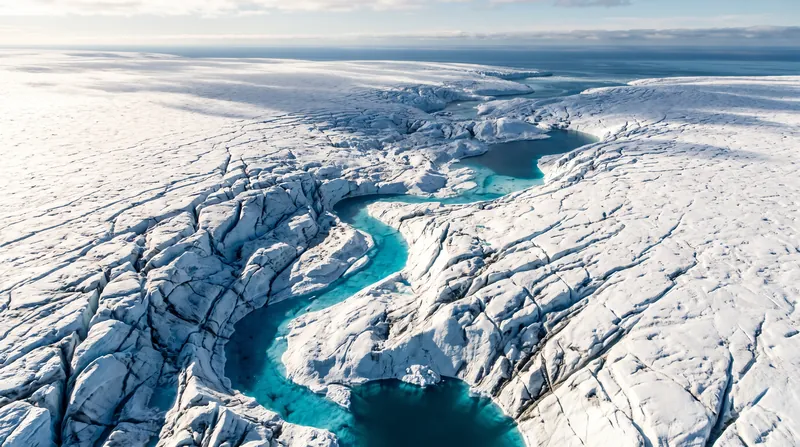
For decades, scientists have observed the retreat of Antarctica's Thwaites Glacier from space, earning it the ominous moniker of the 'Doomsday Glacier.' While satellite altimetry clearly showed the ice shelf thinning and accelerating toward the Amundsen Sea, the exact physical mechanics happening deep beneath the ice remained hidden from direct observation.[1]
That observational gap closed this week with the publication of landmark findings in the journal Nature. Data retrieved by an autonomous underwater vehicle (AUV) deployed through a narrow, 600-meter borehole reveals a highly active, previously unmapped melt mechanism at the glacier's grounding line.
The grounding line is the critical juncture where the glacial ice lifts off the continental bedrock and begins to float on the ocean. Previously, global climate models treated this boundary as a relatively static, sharp transition point where melting occurred at a predictable, steady rate.[3]
The new robotic measurements fundamentally alter this assumption. The AUV detected that high-pressure tidal cycles are actively pumping warm Circumpolar Deep Water up to six kilometers inland beneath the grounded portion of the ice sheet.
This 'tidal pumping' acts like a massive hydraulic wedge. As the ocean tide rises, it lifts the immense weight of the ice slightly, allowing warm, salty water to rush into microscopic cavities and subglacial channels. When the tide recedes, the water is trapped, continuously melting the ice from below.
The implications for the glacier's structural integrity are profound. By melting the ice from beneath the grounded section, the warm water is rapidly degrading the basal friction that holds the glacier back from sliding freely into the ocean.[1]
Thwaites is exceptionally massive—roughly the size of Florida—and currently accounts for about 4% of all global sea-level rise. If the entire glacier were to collapse, it contains enough ice to raise global sea levels by 65 centimeters, or over two feet.[2]
More critically, Thwaites acts as a keystone for the broader West Antarctic Ice Sheet. It physically blocks other major glaciers from flowing into the ocean. If Thwaites is removed, the resulting chain reaction could eventually contribute an additional three meters to global sea levels.[2][3]
The discovery of the tidal pumping mechanism explains a long-standing discrepancy: why satellite altimetry has shown Thwaites thinning faster than traditional thermodynamic models predicted. The older models assumed melting only occurred on the floating ice shelf, not deep inland beneath the grounded ice.[4]
With this new variable introduced, the localized melt rates at the grounding zone are estimated to be 1.5 to 2 times higher than previously calculated. This requires an immediate recalibration of the algorithms used by the IPCC to forecast global ice mass loss.[4]
For coastal planners, these revised physics translate directly into accelerated timelines. Municipalities from Miami to Jakarta rely on decadal projections to issue municipal bonds, zone real estate, and build seawalls.[2][4]
The National Oceanic and Atmospheric Administration (NOAA) and other global agencies are already reviewing the data to determine how it affects the 'extreme' sea-level rise scenarios often used for critical infrastructure planning, such as nuclear power plants and naval bases.[2]
Despite the alarming nature of the findings, researchers emphasize that 'collapse' in glaciological terms does not mean an overnight event. The process will still unfold over decades or centuries, but the timeline has undeniably shifted forward.
The data also highlights the immense value of direct, in-situ observation in extreme environments. The International Thwaites Glacier Collaboration, which funded the AUV deployment, represents one of the most complex logistical scientific endeavors ever undertaken in Antarctica.
Definitions
- Grounding Line
- The exact point where a glacier resting on bedrock detaches and begins to float on the ocean.
- Tidal Pumping
- A process where ocean tides force warm water deep into cavities beneath grounded ice, accelerating melting.
- Circumpolar Deep Water
- A relatively warm, salty ocean current that surrounds Antarctica and is increasingly eroding ice shelves.
- Autonomous Underwater Vehicle (AUV)
- A robotic submarine programmed to navigate and collect data in environments too dangerous for humans.
Questions & answers
Will the Thwaites Glacier collapse tomorrow?
No. In glaciology, a 'collapse' unfolds over decades or centuries. However, the new data suggests this multi-decadal process is happening faster than previously modeled.
How much will sea levels rise if Thwaites melts?
The glacier itself contains enough water to raise global sea levels by about 65 centimeters (over two feet), but it also blocks other ice that could add another 3 meters.
Can we stop the glacier from melting?
Currently, there is no feasible geoengineering solution to stop the subglacial melt. The primary mitigation is reducing global carbon emissions to slow ocean warming.
Analysis by camp
Glaciologists and Modellers
Focus on the physics and the resolution of a long-standing data discrepancy.
For climate scientists, the discovery of tidal pumping is a missing puzzle piece. It resolves a long-standing discrepancy between satellite observations of rapid thinning and the slower melt rates predicted by older thermodynamic models. They argue this proves the necessity of high-risk, in-situ polar research, as satellite data alone cannot capture the complex fluid dynamics happening beneath kilometers of solid ice.
Coastal Adaptation Planners
Focus on the economic and infrastructural shock of accelerated timelines.
For municipal planners and civil engineers, a 1.5x increase in melt rate isn't just a scientific curiosity; it's a fiscal shock. They argue that adaptation budgets must be front-loaded. Infrastructure designed to handle 2060 sea levels may now be overtopped by 2045, requiring immediate reassessments of municipal bonds, zoning laws, and the viability of managed retreat strategies.
Science Communicators
Focus on public understanding and managing climate fatalism.
Communicators emphasize the need to translate complex cryosphere dynamics into actionable public knowledge without inducing paralyzing fatalism. They stress that while the timeline for sea-level rise has accelerated, 'collapse' is still a multi-decadal process. They argue that mitigation (cutting emissions) and adaptation (building resilience) remain highly viable and necessary responses.
- Glaciologists and Modellers
- Focus on the physics, arguing that the discovery resolves a discrepancy between satellite observations and older thermodynamic models.
- Coastal Adaptation Planners
- Focus on the economic and infrastructural shock of accelerated timelines for sea-level rise.
- Science Communicators
- Focus on translating complex cryosphere dynamics for the public without inducing paralyzing fatalism.
Perspectives this story doesn't cover
- Global South coastal communities
- Insurance industry risk assessors
Sources
Source coverage
4 outlets
3 viewpoints surfaced




- [1]BBC NewsScience Communicators
How Oyarzabal shows Spain are more than just Yamal - Azpilicueta
Read on BBC News → - [2]NOAACoastal Adaptation Planners
Global and Regional Sea Level Rise Scenarios: 2026 Update
Read on NOAA → - [3]IPCCGlaciologists and Modellers
Special Report on the Ocean and Cryosphere in a Changing Climate
Read on IPCC → - [4]Factlen Editorial TeamCoastal Adaptation Planners
Synthesis by Factlen editorial team
Read on Factlen Editorial Team →
More in Science
See all →El Niño Forecast
WMO Forecasts Record-Breaking El Niño With +3.7°C Pacific Anomaly
4 sources
Climate Forcing
Why Water Vapour's Nine-Day Lifespan Prevents It From Driving Climate Change
5 sources
Radiative Transfer
The Emission Altitude Shift: Why Saturated Carbon Dioxide Bands Continue to Warm the Planet
10 sources
Climate Thresholds
The Nine Climate Tipping Elements and the Temperature Thresholds That Trigger Irreversible Change
8 sources
Comments
Every angle. Every day.
Get Science stories with full source coverage and perspective breakdowns, free every day.